|
 |
Click on a thumbnail to zoom in.
|
|
|
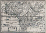
[Africa] Mercator, Gerard -Hondius, Jodocus, Africæ Descriptio, Amsterdam (c.1630). 5.5 x 8" (14 x 19 cm). Copperplate engraving; uncolored. Reverse blank. $275.
A map ahead of its time—crammed full of place names. Engraved by Abraham Goos. |
![[Ottens]](/images/thumbs/africa.ottens.n00137.ed-2.jpg) |
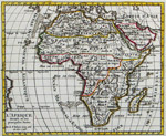
[Africa] Ottens, Reiner & Josua, L’Afrique Dressée sur les Observations de Mrs. De l’Académie Royale des Sciences et quelque autres; et sur les Mémoires les plus recens par G. De L’Isle…, Amsterdam, [ca. 1740]. 17.5 x 22.5″ (44.5 x 57 cm). Copperplate engraving; original wash color. $995.
A striking, large remarkably imaginative map of Africa issued by the Ottens brothers after De L’Isle’s map. An indigenous person wrestles a crocodile while a facsimile of an ostrich attempts flight and a herd of fat elephants look outward from the cartouche. Apparently bound twice, once with it folded in the middle, as usually found, and once bound along its left side with the map open. Evenly browned; dampstains in the margin. |
|
[Africa] Robert de Vaugondy, Gilles, L’Afrique Divisée en ses principales Parties…, Paris, 1748. 6.25 x 7.5" (16 x 19 cm). Copperplate engraving; original outline color. $85.
Published in the Atlas Portatif (1748-49). Indicates giant beds of seaweed west of the Canaries and just north of the Tropic of Capricorn. |
|
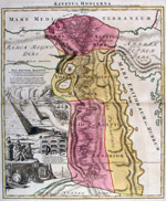
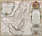
[Africa/Egypt] Homann, Johann Baptist, Egyptus Hodierna, Nuremberg (c. 1720). 21.75 x 18.5" (55.5 x 47 cm). Copperplate engraving; original wash and outline color. $775.
Engraved by J. B. Homann’s son, Johann Christoph Homann, this extravagantly decorated map includes vignettes of the Nile cataracts, the pyramids, tombs, towns, walled villages and antiquities. On a full, uncut sheet with deckle edges on all sides. |
|
[Africa, West] Blome, Richard, Africa or Libia Ulteriour where the Countries of Saara Desert the Countrie of Negroes and Guine with the Circumjacent Countries and Kingdoms…, London (1682). 11.25 x 16" (26 x 40.5 cm). Copperplate engraving; original outline color. $650. Blome dedicated this map to the officers of “the Honorable Company of Royall Adventurers of England tradeing into Affrica,” and included a handsome crest, presumably belonging to the Adventurers. He first published this map in 1670 in his Geographical Description of the Four Parts of the World and reused the plate in 1682 when he published it in Bernhard Varenius’ Cosmography and Geography, from which this example comes. The map is based on the work of the French cartographer Nicolas Sanson, which Blome acknowledges in the title. Printed with plate tone in the top left corner.
|
|
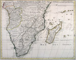
[Africa, Southern] Delisle, Guillaume, Carte du Congo et du Pays des Cafres par G. De l’Isle de l’Acadaemie Royale des Sciences and Premier Geographe du Roy [added later], Paris, 1708, but after 1718. 19.25 x 24.25" (49 x 62 cm).
Copperplate engraving; original outline color. $675. Dated 1708 inside the bottom neatlines but with the addition of the title as First Geographer to the King, which Delisle became in 1718. An interestingly detailed map with a few smudges in the Indian Ocean. |
|
[Africa, North] Moll, Herman, The West Part of Barbary together with The East Part of Barbary, London, 1732. 8 x 10.5" (20 x 27 cm). Copperplate engraving; original outline color. Two maps on one sheet. $75. From Moll's Atlas Minor. Largely dampstained in a fairly unobtrusive manner. |
|
|
|
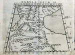
[Middle East/Armenia] Ruscelli, Girolamo, Tabula Asiæ III, Venice (1574). 7 x 9.75" (18 x 24.5 cm). Copperplate engraving; uncolored. $225. With the Black Sea to the west and the Caspian on the east this Ptolemaic map names Armenia Major and Minor. Printed on fine heavy paper. |
|
|
|
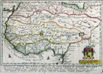
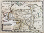
[Middle East/Holy Land] Moullart-Sanson, Pierre, Description Géographique de la Terre Promise, Terres des Hébreux et des Israelites…Paris (1716). 14 x 16" (35.5 x 40 cm) Copperplate engraving; modern outline and wash color. $350. The Promised Land, as divided among the Twelve Tribes, with a large cartouche with drapery held by several putti, published in Moullart-Sanson's Géographie Sacrée in 1716. Moullart-Sanson was the grandson of the famous cartographer Nicolas Sanson, the elder, and uncle of G. Robert de Vaugondy, another influential French cartographer. A small repaired paper loss extending into the neat lines near the bottom center.
|
|
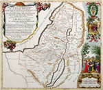
[Middle East/Holy Land] Moullart-Sanson, Pierre, La Judée ou Palestine sous le Roi Herodes…, Paris (1716). 13 x 15.5 (33 x 39 cm). Copperplate engraving; modern outline and wash color. $350. Judea under King Herod from Moullart-Sanson's Géographie Sacrée. Moullart-Sanson was the grandson of the famous cartographer Nicolas Sanson, the elder, and uncle of G. Robert de Vaugondy, another influential French cartographer.
|
|
[Middle East/Holy Land] Moullart-Sanson, Pierre, Les Voiages de Notre Seigneur Jesus Christ et des Apôtres St. Pierre et St. Paul dans L’Asie, L’Afrique et L’Europe, Paris (1716). 14 x 16.5" (35.5 x 32 cm) Copperplate engraving; modern outline and wash color. $350. From Moullart-Sanson’s Géographie Sacrée. The cartouche is surrounded by Christ and Sts Peter and Paul. The routes taken through the western Mediterranean and Asia Minor by Peter and Paul are marked. A wind rose in the Mediterranean names the eight winds in accordance with the New Testament. Moullart-Sanson was the grandson of the famous cartographer Nicolas Sanson, the elder, and uncle of G. Robert de Vaugondy, another influential French cartographer. |
|
[Middle East/Holy Land] Brion [de la Tour], Louis/Desnos, Louis-Charles, La Judée ou Palestine Dressée pour l’Intelligence de l’Histoire Sainte, Paris (c. 1766). 10.25 x 11.75 (26 x 30 cm). Copperplate engraving; original outline and wash color. $275. An attractive, nicely colored map set into a decorative engraved frame, which was printed from a separate copperplate. Trimmed close at the bottom.
|
|
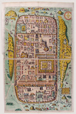
[Middle East/Jerusalem] Adrichom, Christian [Adrichem, Christiaan van], Jerusalem et suburbia eius, sicut tempore Christi floruit…descripta per Christianum Adrichom Delphum, Cologne, 1584 but probably after 1590. 20 x 29.5" (51 x 75 cm). Copperplate engraving; possibly old color with possibly modern embellishment; heightened with metallic gold and silver. $3,600.
Biblical Jerusalem oriented with east at the top. Most early maps of Jerusalem were based on the Bible rather than actual geography. This map is "the richest and most detailed" of these maps with over 280 named and numbered sites from both the Old and New Testaments. Nebenzahl says that "Adrichom’s delineation of Jerusalem is the most dramatic and important of the 16th century." Significantly, it is the first map to depict the fourteen Stations of the Cross as they are most widely accepted today.
The copper plate that this impression was taken from had three breaks in it, the breaks printing as jagged lines. Here, the jagged lines have been painted over. Two out of three of these breaks are seen on the 1590 impression of this map (see Jewish National and University Library, Jerusalem), indicating that the present map was printed later. The printing plate deteriorated further and the map was eventually re-engraved, keeping the 1584 date until 1692, when the date was finally changed. One repaired tear into the image near the center left; misfolds at the centerfold.
Tishby, p. 30; Nebenzahl, p. 90.
|
|
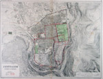
[Middle East/Jerusalem] Braun, Georg & Hogenberg, Frans, Jerusalem, et suburbia eius sicut tempore Christi floruit… Cologne (1588). Two sheets joined, 29.5 x 19" (48 x 74.5 cm). Copperplate engraving; modern color. $3,450.
Braun and Hogenberg copied Adrichom’s map of Jerusalem, giving him credit in the title, but made significant changes to it. The new map is oriented with north to the top, with corresponding changes in the buildings and walls. It appeared in the fourth volume of their Civitates Orbis Terrarum, the most impressive and elaborate collection of city views ever produced. It was through the Braun and Hogenberg copy that Adrichom’s work earned its fame. A repaired tear entering the image at the center right side.
Tishby, p. 30; Nebenzahl, p. 90. |
|
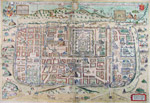
[Middle East/Jerusalem] Smith, William, Jerusalem Ancient & Modern, London (1874). 17 x 22.75" (43.5 x 57.5 cm). Steel engraving; original wash color and printed color. $75. A highly detailed map of modern Jerusalem with printed overlays indicating "ancient remains and names" in biblical times, according to Josephus, and in the medieval era. Dampstained at top and bottom, not affecting the image; repaired split at centerfold. |
|
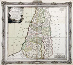
[Middle East/Palestine] Lapie, Pierre, Palestine, Paris (1828).11.5 x 9.75" (2.5 x 22.5 cm). Copperplate engraving; original outline color. $85. The Holy Lands under the Romans, with an inset plan of Jerusalem. |
|
[Middle East/Palestine] Colton, J. H., Palestine, New York, 1855(1859). 11.75 x 14.75" (37.5 x 30 cm). Stone lithograph; original hand color. $75. With an inset of the Arabian peninsula. Evenly browned, light offsetting. |
|
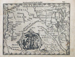
Paradise Found!
[Middle East/Paradise] Mercator, Gerard-Hondius, Jodocus, Paradisus, Amsterdam (French ed.,1608). 5.75 x 7.5? (15 x 19 cm). Copperplate engraving; uncolored. $425. Paradise is roughly located between the Euphrates and Tigris Rivers, marked here by a tiny engraving of two figures standing before a snake-entwined tree. The much larger medallion shows Eve offering Adam an apple as a serpent entwined in an apple tree looks on. From the 1608 French edition of the Mercator-Hondius Atlas Minor. Some soiling in the margins. |
|
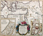
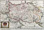
[Middle East/Persia] Blome, Richard, A Mapp of the Empire of the Sophie of Persia with its Severall Provinces designed by Moncr. Sanson, Geographer to ey French King, London (1682). 10.25 x 15.5" (26 x 39.5 cm). Copperplate engraving; original outline and wash color. $650. Blome first published this map in 1670 in his Geographical Description of the Four Parts of the World. He reused the plate in 1682 when he published it in Bernhard Varenius' Cosmography and Geography, from which this example comes. The map is based on the work of the French cartographer Nicolas Sanson, which Blome acknowledges in the title.
|
|
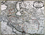
[Middle East/Persia] Delisle, Guillaume/Buache, Philippe, Carte de Perse dressée pour l’usage du Roi…Decembre 1724, Paris, 1724/1745. 19.25 x 24.5" (49 x 62 cm). Copperplate engraving; original outline color. $600. A detailed map showing many trade routes and containing innumerable interesting notes, this map by Delisle, a key figure in the history of French cartography, was reissued in 1745 by his son-in-law, Buache, considered one of the foremost French geographers of the eighteenth century. Buache added his name and date at the bottom right, inside the neat lines. Two unobtrusive creases through the top half. |
|
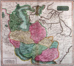
[Middle East/Persia] Thomson, John, Persia, Edinburgh (1817). 17.5 x 20" (45 x 50.5 cm). Copperplate engraving; original wash color. $195. Encompassing all of the area from the Persian Gulf to the Caucasus. Some offsetting. |
|
[Middle East/Turkey] Moll, Herman, Turky in Asia or Asia Minor & c. Agreable to Modern History, London, (1730-32). 7.75 x 10.25" (20 x 26 cm). Copperplate engraving; original outline color. $75. From Moll's Atlas Minor. Largely dampstained but in a mostly unobtrusive manner.
|
|
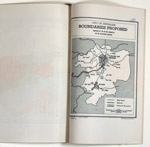
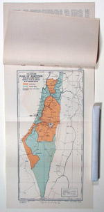
[Middle East/Israel] United Nations, Resolution 181: General Assembly Resolutions Adopted on the Report of the Ad Hoc Committee on the Palestinian Question, 29 November 1947. Original printed document comprised of 21 stapled pages and two maps, each in an English version and in a French version. Contained in a blue linen folder lined with blue silk inside a blue linen clamshell box with leather label. Fine condition but for rust around the binding staples. $800.
The maps are:Palestine Plan of Partition with Economic Union Proposed by the Ad Hoc Committee on the Palestinian Question, 18 x 9" (45.5 x 38 cm); printed in two colors and present in two examples, one in English and one in French.
City of Jerusalem Boundaries Proposed by the Ad Hoc Committee on the Palestinian Question, 9.5 x 6.5" (22 x 16.5 cm), uncolored. The boundaries of Greater Jerusalem, including Bethlehem. Present in two examples, one in English and one in French.
One of the pivotal moments in the modern history of the Middle East and of the State of Israel was the adoption of Resolution 181 by the United Nations General Assembly on November 29, 1947. The Resolution called for the partition of the British Mandate territory of Palestine and would have partitioned the territory of Palestine into Jewish and Arab states, with the Greater Jerusalem area, encompassing Bethlehem, coming under international control. The Jews in Palestine accepted the resolution, but the Arabs in Palestine and the Arab states did not. The subsequent war resulted in an enlarged Israel declaring its independence on May 14, 1948.
|
|
|
© 2009-2014 Susan Benjamin Rare Prints & Maps. All Rights Reserved. |
|
|
|
|