|
 |
Click on a thumbnail to zoom in.
|
|
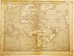 |
Münster, Sebastian, La table des Isles neufues, lesquelles on appelle isles d’occident & d’Indie pour divers regardz. Basel, 1540 [1552-1555]. 10 x 13.5″ (25.5 x 34.2 cm). Woodcut; uncolored. State 5, French text. $3,950. Sold
Sebastian Münster (German, 1488-1552), a Franciscan priest who married his printer’s widow, is famous for his many editions of Ptolemy’s Geographia, first issued in 1540, to which he added several modern maps, this map being one of them. This map of the Americas is the earliest map of the Americas of any note. It was not the very first map to use the name “America” but it is of great significance that Münster used the name (in the southern continent) on this map for by doing so he established the name of the continent forever as America.
The map which appears so distorted to us today was cut less than fifty years after Columbus’ first voyage, yet it contains many familiar place names: Florida, Cuba, Jamaica, Hispaniola, Dominica, and the Straits of Magellan. To the west the influence of Marco Polo is shown in the naming of Zipangri (Japan).
This 450+ year old map shows its age. It is stained, soiled and has suffered various tears and paper losses It has numerous old repairs visible on the back. Priced accordingly.
Burden, 12.
|
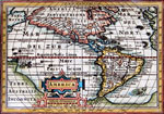 |
Bertius, Petrus, America, 1616-18. 3.75 x 5.24" (9.5 x 13.5 cm). Copperplate engraving; modern color. $625.
Jodocus Hondius, Jr. published the 1616 enlarged edition of Bertius' Tabularum Geographicarum Contractarum, which contained this map of the Americas. The Hudson Bay appears here for the first time on a continental map. Printed on the reverse side is the title page to Book Seven of the Tabularum. Trimmed close at the top, shaving the title; damp stained in the margins. Burden, 183. |
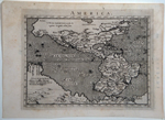 |
Magini, Giovanni Antonio, America, Venice, [1596]. 5.0 x 7.0″ (12.7 x 17.5 cm). Copperplate engraving; uncolored. $750.
This finely engraved miniature map was published in the first printing of Magini’s new edition of Ptolemy’s Geographia. It was borrowed from an earlier Venetian mapmaker who in turn had borrowed it from Ortelius’ 1570 map. The potato shape of South America is what distinguishes all of these maps, something Ortelius had corrected by 1587. Although the interior of North America is described as an unknown region, the Sierra Nevada is named along the West Coast and C. Californicus is named at the tip of Baja. On the east coast Canada, Apalchen (Appalachia), Florida and many Caribbean islands and countries in Latin America already bear their present names.Minor spotting.
Burden, 93. |
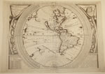 |
Coronelli, Vincenzo Maria, Planisfero Del Mondo Nuovo, Descritto Dal P. Coronelli, Cosmosgrafo Publico, Venice, [1691, state 2]. 17.9 x 23.9″ (45.5 x 60.5 cm). Copperplate engraving; uncolored. Western sheet only of a two sheet map. $3,250.
Acknowledged as one of the most beautiful maps by Coronelli who is known for his beautiful maps. Coronelli (Venetian, 1650-1718) gained famed first for his globes when in 1683 he completed a pair of globes for King Louis XIV of France which were thirteen feet in diameter.* In 1688 he produced a three foot globe with engraved gores patterned after Louis’ globe. The present map is based on those gores. Although the map is dated 1688 it was not published in the Atlante Veneto until 1691. California is shown as an island and the mouth of the Mississippi is located deep in the heart of present day Texas. The concentric tables surrounding the map give equivalent distance tables, eclipse and astronomical data. The zodiacs are placed outside the tropics above which they are seen. Centerfold reinforced; restored paper loss at top center not affecting the image; small paper loss along centerfold south of the equator, not affecting printed areas. Framed.
Burden, 677; McLaughlin 105
*For a look at this fantastic globe, see http://expositions.bnf.fr/globes/index.htm and check every link. It’s in French, but you don’t have to understand the language to appreciate the globe. |
|
|
© 2009 Susan Benjamin Rare Prints & Maps. All Rights Reserved. |
|
|
|
|