 |
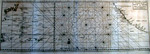
PACIFIC OCEAN Anson, George, Carte de la Mer du Sud ou Mer Pacifique entre l'Équateur et le 39½ de Latitude Septentrionale, c.1748. 11.5 x 34.25" ( 29.5 x 87 cm). Uncolored copperplate engraving. $295
Anson left England in 1740 with nine ships and 961 men with orders to disrupt Spanish operations on the west coast of South America and to capture Spanish galleons. Most of his ships failed to round the Horn and he eventually was left with only his flagship, the Centurion. After one of the most arduous voyages in history, he sucessfully captured the enormously rich galleon, Nuestra Señora de Covadonga and seized more than 1.3 million pieces of eight. This chart traces the routes of the Centurion and the Nuestra between Acapulco and The Philippines. For more of this fascinating story click here. |