|
 |
Click on a thumbnail to zoom in.
|
|
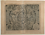 |
Quad, Matthias, Polus Arcticus sive Tract Septentrionalis Coloniæ, ex officina typographica Jani Buffemechers, Cologne [1600]. 8.5 x 10.75″ (21.5 x 27.5 cm). Copperplate engraving; uncolored. $1,175.
Quad based his map on the arctic map contained on Gerard Mercator’s great world map published in 1569 and the later, smaller maps by his heirs, yet made significant modifications and additions. A cliff labeled in Latin as “high, black cliff” sits in the center of the arctic. This is the legendary magnetic mountain, the magnetic north pole. Interestingly, Mercator’s map shows two additional sites for the magnetic pole (look towards center from 180?), both copied by Quad. California is named and resides inside the arctic circle. A navigational northern passage around the New World exists with the open route through the Straits of Anian (at 180?), a route not navigated until recently. For an interesting discussion of this map, see the strangemaps blog at http://strangemaps.wordpress.com/2007/05/24/116-the-first-false-map-of-the-%E2%80%98true-north%E2%80%99/ . Paper evenly browned. Burden, 134.
|
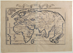 |
Fries, Lorenz – Waldseemüller, Martin, Diefert Situs Hydrographorum ab eo quem Ptolomeus Posvit [“Tabu. Nova Orbis” in banner], Lyon [1535]. 11 x 18″ (28 x 45.5 cm). Woodcut; uncolored. $5,400.
This “unsophisticated but attractive” map is one of the earliest world maps available to the collector. Fries included it as the modern world map in his edition of Ptolemy which he first published in 1522 in Strasbourg. He copied it from Waldseemüller’s 1513 world map, but added the five kings who represent Russia, Egypt, Ethiopia, Taprobana (Ceylon) and the Hittite King Mursuli, who is placed far east of his home, and the mammoth near Greenland. The western hemisphere is suggested with only a squiggle in the north and a bit of Brazil in the south. A fine, dark impression; tiny bits of paper loss at the centerfold, which is slightly discolored; light scattered foxing; paper cockled radiating from the centerfold on both sides. Shirley, 49.
|
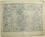 |
Münster, Sebastian, Das Erst General Inhaltend die Beschreibung und den Circkel des Gantzen Erdtrichs und More, Basle [1550-78]. 10.25 x 15″ (26.5 x 38 cm). Woodcut; uncolored. $2,950.
The world on an oval projection surrounded by a dozen named windheads projecting out of intestinal clouds. The Caspian Sea runs east to west. The outline of the New World is easily recognized in the west, although North America (labeled Terra Florida or Florida-land) is nearly cut in two by a large body of water. The west coast of North America appears in the far east labeled Temistitan (the then common name for Mexico). While not on a map for the first time, the name America appears here. Burden states that this inclusion in the Cosmographia, which was extremely popular and went to forty editions in four languages over a period of a hundred years, sealed the fate of America as the name for the New World. From a German text edition of Münster’s Cosmographia, with the monogram of the woodcutter, David Kandel, at the bottom left. Grubby margins; repair to the centerfold with some loss, repaired holes and some paper added to the edges; a few thin spots. Shirley, 92. Burden, 12 (as to the companion map of the Americas).
|
 |
California as an island
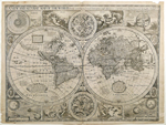
Speed, John, A New and Accurat Map of the World Drawne according to ye truest Descriptions latest Discoveries & best Observations yt have beene made by English or Strangers. 1626. …Are to be sold in popshead Allee by Georg. Humble. London, 1626 [1627]. 15.5 x 20.25″ (39 x 51.5 cm). Copperplate engraving; uncolored. $24,000.
The first state of the first world map published in an atlas to show California as an island, contained in the first world atlas published by an Englishman.
This map has something for everyone! The double hemispheres are surrounded by a multitude of figures and spheres: in the four corners are an astronomical table, an armillary sphere, and eclipses of the sun and moon. Celestial charts for the northern and southern skies sit above and below the hemispheres; the Four Elements, Water, Earth, Fire and Air, are pictured allegorically, and there are portraits of four of the great discoverers: Drake, Candish, Magellan and Vander Noort. According to Shirley Speed’s atlas was not as widely disseminated as other contemporary atlases by Mercator-Hondius, Jansson or Blaeu, and consequently “the demand for the world map—long recognized as a very desirable collector’s item—has enhanced it rarity value.” Short split at the bottom of the centerfold; printer’s crease on the left side running from top to bottom and two additional shorter printer’s creases; chips and soiling in the margins; soft creases at both bottom corners. Shirley, 317.
Pasted down on the verso is a printed owner’s label bearing the hand-written date June 23, 1915. This collector usually recorded the date of his purchase on a label that he affixed to his maps. This map was purchased from the estate of the collector’s nephew, who received it by descent. The collector often recorded the name of the mapseller, but unfortunately did not do so on this occasion. Other than the sale to me, this is the first time this map has been offered for sale since 1915.
|
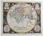 |
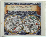
Danckwerth, Kasper and Meyer, Johann, Orbis Vetus Cum origine magnarum in eo gentium a filiis et nepotibus Noe….Christian Rothgiesser Husum sculpsit, Ano 1651, Husum, 1651[1652]. 17 x 21″ (43.5 x 53 cm). Copperplate engraving; modern color. $1,495.
A richly ornamented map of the eastern hemisphere, surrounded by putti and garlands of fruit and grapes and wine bottles, a walled garden and windheads.
Danckwerth and Meyer published an atlas of maps of the German province of Schleswig-Holstein in which they included this classical representation of the eastern hemisphere, which stands alone without a corresponding map of the western hemisphere. The engraver, Christian Rothgiesser, both signed and dated this finely drawn map. The lower two cartouches list the descendants of Noah. Presumably, the tracks on the map are the peregrinations of Noah’s heirs in their quest to repopulate the earth. Remargined at top and bottom; rebacked. Shirley, 388. |
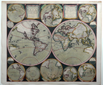 |
California depicted as an island five times
Allard, Carel, Planisphærium Terrestre, Sive Terrarum Orbis…[with title repeated in Dutch], Amsterdam [1696]. 20.5 x 23.5″ (52 x 59.5 cm). Copperplate engraving; original outline and wash color. $8,950.
This is one of the most beautiful map I have ever had. Its composition, design, content and full original color evoke a deep appreciation for the artistic elements of fine mapmaking.
Allard (1646-ca. 1706) surrounded the double hemispheres with eight smaller projections showing the earth from different angles along with four other smaller circular diagrams. California appears as an island in five of the ten projections. This map is the first in which the engraver filled the empty space surrounding the hemispheres with cross-hatching, which printed very dark, and produced a strikingly dramatic contrast to the rest of the map, a technique later adopted by several other great mapmakers. Restoration at centerfold; the top right and the two lower circular diagrams have restored cracks and/or holes with some paper loss; rebacked. Shirley 578. |
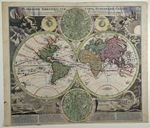 |
[World] Homann, Johann Baptist, Planiglobii Terrestris Cum Utroq Hemisphærio Cælesti…. , Nuremberg [ca. 1730]. 19 x 21.25″ (48 x 54 cm). Copperplate engraving; original outline and wash color. $3,750.
An extravagantly decorative double hemisphere world map.
The two hemisphere a with the world bordered above and below by two celestial charts containing a multitude of constellations in the northern and southern skies nestle between the two hemispheres. To each side of the upper celestial are small diagrams of the position of the sun relative to the earth in summer and in winter. Windheads in the starry heavens blow on the earth while two torch-bearing cherubs hold the title banner aloft. At the bottom left, Mt Ætna erupts and earthquake and floods destroy a town while nearby villagers pray on their knees. To the right is a ship keeping a safe distance from a whirlpool and a large group of waterspouts while elsewhere is a more tranquil scene of rain and a rainbow. On the hemispheres themselves the direction of the ocean currents are indicated by arrows and wind currents are also indicated. The map tracks several circumnavigations. Trimmed close at the bottom; misfolds at the centerfold; some place names in Europe and the Pacific underlined by hand; two splotches of writing ink and a few other spots of an unknown nature here and there.
|
 |
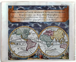
[World] Doppelmayr, Johann Gabriel, Basis Geographiæ Recentioris Astronomica, Nuremberg [1716-1724, 1742]. 19 x 22.75″ (48 x 58 cm). Copperplate engraving; original outline color. $1,600.
Johann Doppelmayr was an accomplished astronomer who had a life long collaboration with Johann Baptist Homann and his heirs. This plate by Doppelmayr was first published by Homann between 1716 and 1724 and was used again by Doppelmayr when he published his Atlas Coelestis in 1742, in which this map appeared as Plate 15 (see top right corner of the map for the number). This simple double hemisphere plate shows the track of an eclipse crossing the equator. The hemispheres are surrounded by engravings of a comet and solar and lunar eclipses. Below the hemispheres winged figures (a little too old to be putti) are shown making astronomical observations with various instruments. The tables above and below the map give the eclipse observations made by astronomers across the world, including Flamsteed and Halley in England and Tycho Brahe in Prague (Germania here). The astronomers could calculate the trajectory of the shadow across the earth during an eclipse with some precision, even at that time: the position of the sun was known; the tilt of the earth with respect to the sun was knowable as was the orbit of the moon, and from these things the location of the shadow spills out. A thin spot in the lower margin.
For a good discussion of Doppelmayr’s life and accomplishments and to see all the plates of the Atlas Coelestis go to http://www.phys.uu.nl/~vgent/doppelmayr/doppelmayr.htm |
|
California as an Island
Buffier, Claude, Mappe-Monde ou Carte Générale du Globe Terrestre représentée en deux Hémisphères together with Le Globe Céleste Ou on voit 1022 Etoiles en 48 Constellations, 12 dans le Zodiaque et 36 hors du Zodiaque, etc., Paris [1792]. Two maps printed on two sheets, each map measuring 5.75 x 6.5″ (14.5 x 16.5 cm). Copperplate engravings; modern wash color. $435., the pair. SOLD
A charming miniature pair. Buffier was a Jesuit theologian and geographer from Warsaw who worked in Paris. These maps were published in a late edition of his Géographie Universelle.
|
 |
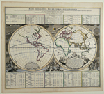
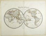
Brué, Adrien Hubert, Carte Générale du Globe Terrestre par A. H. Brué Géographe de S. A. Royale Monsieur à Paris chez J. Goujon, Paris, 1821. 22 x 33.75″ (56 x 85.5 cm). Copperplate engraving; original outline color. $625.
An attractive, large double hemisphere map with the prime meridian at Paris. With the publisher’s blind stamp. One small hole and several thin spots on the right side in blank areas; light foxing at the bottom; repaired centerfold. |
 |
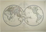
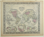
Lapie, Pierre & Lapie, Alexandre Émile, Mappe-Monde en Deux Hémisphères par Mr. Lapie, Lieutenant Colonel et Lapie fils Lieut. d’État Major, Paris, 1831[1832]. 13 x 22″ (33 x 55.5 cm). Copperplate engraving; original outline color. $295.
Lapie father and son worked together to produce the Atlas Universel de géographie ancienne et modern, which was popular and went to many editions. |
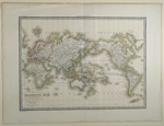 |
Lapie, Pierre & Lapie, Alexandre Émile, Mappe-Monde sur la Projection de Mercator Dressée par Mr. Lapie, Colonel d état Maj’r et Mr. Lapie fils Capitaine d’État Major, Paris, 1838. 15.75 x 21.5″ (39.5 x 54.5 cm). Copperplate engraving; original outline color. $295.
An attractive map centered on the Pacific, it is from a later edition of the Atlas Universel than the double hemisphere map above. A soft crease from top to bottom on the right side.
|
 |
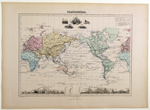
Mitchell, Samuel Augustus, The World in Hemispheres with Other Projections &c. &c., Philadelphia, 1860 [1866]. 11 x 13″ (28 x 33 cm). Steel engraving; original wash color. $165.
With two projections of the north pole, one of the south and projections showing the hemispheres having the greatest land mass and the greatest body of water. At the top is a comparison of the rivers of the western and eastern hemispheres. A few spots; browning at the edges.
|
 |
Migeon, J., Planisphère, Paris [1884]. 10.5 x 14.75″ (27 x 37.5 cm). Steel engraving; original wash color. $95.
This nicely engraved map contains a wealth of information that one does not need to read French to understand, although you will need a magnifying glass. Alongside countless place names are listed their dates of discovery, the names of the discoverer and his country. Land and sea routes are marked as are the overland and trans-ocean routes of telegraph lines. Across the bottom of the map is a comparison table of mountain heights. A useful map. |
|
|
© 2009-2014 Susan Benjamin Rare Prints & Maps. All Rights Reserved. |
|
|
|
|