|
 |
Click on a thumbnail to zoom in.
|
|
 |
NORTH AMERICA
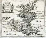
de Fer, Nicholas, Amérique Septentrionale, 1689. 5.5 x 6.5" (13.5 x 16.5 cm). Uncolored copperplate engraving. $625.
This map appeared in Jacques Robbe's Méthode pour Apprendre Facilement la Géographie and is among the earliest known works by Nicholas de Fer. It was engraved by Jean Baptiste Liebaux and shows California as an island with an indented northern coastline. Very faint offsetting from having been folded, as issued. Burden, 604, state 3; McLaughlin, 100.
|
| |
de Rossi, Giovanni G., L'America Settentrionale. Nuovamente corretta et accresciuta secondo le relationi piu moderne da Guglielmo Sansone Geografo di S.M. Christianisa….1677. Rome, 1677. 15.25 x 21.25″ (39.0 x 54.0 cm). Copperplate engraving; original outline color. State 1. $3,750.
In 1677 de Rossi published his Mercurio Geografico, an atlas of maps taken almost entirely from the works of the Sanson family in France, whether with or without their permission is unknown. He did acknowledge G. Sanson in the map’s title, however.
California is shown as an island on the Foxe model of 1635. To the east Canada is named while New France occupies most of the northeast of the continent. The small colonies of New England, the Low Countries (the Netherlands) with New Amsterdam (the city of New York), and a large Virginia are named. One repaired tear entering the plate at the top; two small repaired worm holes inside the image, not affecting the printed area; a few worm holes in the margins; rust or glue stains in the left margin; a few smudges.
Burden, 491. McLaughlin, 65. |
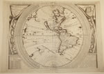 |
Coronelli, Vincenzo Maria, America Settentrionale Colle Nuoue Scoperte fin all’ Anno 1688…Venice, 1688 [1691]. 23.6 x 17.75″ (60.2 x 45.3 cm). Copperplate engraving; uncolored. The western sheet only of a two sheet map. $9,500.
Coronelli is famed for both the incredibly beautiful globes that he produced and the fine cartography and mapmaking that went along with them. In 1683 he completed the commission for a pair of globes for King Louis XIV of France which were thirteen feet in diameter.* In 1688 he produced a three foot globe with engraved gores patterned after Louis’ globe, and, like his map of the Americas, the present map is based on those gores. Although the map is dated 1688 it was not published in the Atlante Veneto until 1691. It provided a major leap in the cartography of the day even though it contained two very glaring mistakes: that California was an island (which Coronelli questions in a legend just west of California) and that the Mississippi River was some 600 miles farther west than it actually is, almost to the Rio Grand. But for the first time he correctly depicted the Rio Grand emptying into the Gulf of Mexico and not the Gulf of California. He was the first to place a mountain range on the eastern side of California (the Sierra Nevada). A smudge of printer’s ink at the top margin, else in fine condition.
Burden, 643; McLaughlin, 103.
*For a look at this fantastic globe, see http://expositions.bnf.fr/globes/index.htm and check every link. It’s in French, but you don’t have to understand the language to appreciate the globe. |
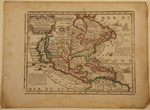 |
Chiquet, Jacques, L'Amerique Septentrionale qui fait partie des Indes Occidentales…. Pais Chez Chiquet, 1719. Paris, 1719. 6.4 x 8.5″ (16.3 x 21.9 cm). Copperplate engraving; original outline color. $850.
A charming, small map made priceless by its declaration in the lower left corner that California is one of the largest islands of the World! And it goes on to give the island’s exact dimensions. The map appears to be based on Coronelli’s with the Mississippi’s mouth near the Rio Grande. Many of the English colonies are shown on the east coast but Nouvelle Holland is still named. Damp staining in the lower margin to just outside the neat line; a few worm holes in the left margin; soiling in the margins.
McLaughlin 191. |
|
|
© 2009-2014 Susan Benjamin Rare Prints & Maps. All Rights Reserved. |
|
|
|
|