|
 |
Click on a thumbnail to zoom in.
|
|
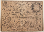 |
de Bry, Theodore, Occidentalis Americæ partis, vel, earum Regionum quas Christophorus Columbus prim? detexit Tabula Chorographicæ multorum Auctorum Scriptis, præsertim verò ex Hieronymi Benzoni ... Theodoro de Bry Leod. Anno M D XCIIII. Frankfurt, 1594. 13 x 17.25″ (33 x 44 cm). Copperplate engraving; uncolored. $8,950.
Dated 1594, this is one of the grandest, earliest available maps of the region. It is a fine example of the mapmaker’s art of the 16th century. It centers on the Caribbean and also includes much of the southeast and gulf coasts of North America and the Yucatan, Central America and northern coasts of South America. The map is amazing for all that it got right even though the islands are too large and Grand Bahama too far north. There are many recognizable place names: Florida, Canaueral, Merida, Gvatimala, Honduras, Nicaragua, Panama, Benezuela, and several notations regarding Columbus’ landings. It was published in the fourth volume of de Bry’s Grand Voyages, which recounts the travels of Girolamo Benzoni between 1541 and 1556. The depiction of Florida is based on de Bry’s earlier map, Floridae Americae which in turn was taken from the mapping of Florida by the Frenchman LeMoyne, 1591.
The map is evenly browned, trimmed within the border at the bottom, with thread margins at the top, centerfold reinforced.
Burden, 83.
|
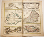 |
Homann Heirs, Dominia Anglorum in praecipuis Insulis Americae ut sunt Insula S. Christophori Antegoa Iamaica Barbados nec non Insulae Bermudes vel Sommers dictae ... Nuremberg, 1740. 19.25 x 21.75 in (48.5 x 55 cm). Copperplate engraving; original outline color. $595.
Five maps on one sheet: St Kitts, Antigua, Bermuda, Barbados and Jamaica, which were all British colonies at the time. Each map contains considerable detail. In deference to the publisher’s English clientele, the cartouche contains a table with translations of basic German place descriptions into English.
The Homann family were the most important map publishers in Germany in the 18th Century. J. B. Homann (1663-1724) began business in Nuremberg in 1702 and later became a member of the Berlin Academy of Sciences and Geographer to the Emperor. His son Johann Christoph succeeded him in 1724 and it was his heirs who continued the business into the 19th century. They were a major influence in map publishing.
A few printer’s creases, most notably along the centerfold; a strip of paper skinned on the reverse to the left of Jamaica, with a small, old patch on the reverse; discoloration at the centerfold, minor soiling in margins, former owner’s blind stamp in margin at bottom left corner. |
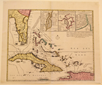 |
Ottens, Reinier & Josua, Nova Tabula Exhibens Insulas Cubam et Hispaniolam vulgo S. Domingo Dictam Insulas Lucaias seu Bahamanas ac Peninsulam Floridae ... Amsterdam, c. 1740. 17.5 x 21.25 in (44.5 x 54 cm). Copperplate engraving; original wash color. $3,950.
The Ottens brothers published this map of the Caribbean between 1720 and 1750 in their Atlas Major, which was a huge work usually assembled to order and sometimes running to as many as fifteen volumes and 800 maps. The most commonly given date for this map is 1740. It contains insets of St Augustine (Florida), Havana and Santo Domingo and is written primarily in French but contains Dutch and English notes. The Caribbean routes of the Spanish galleons from Cartagena to Havana and from there to Spain are described. This is the upper sheet of a two sheet map. It is in fine condition but for three pin holes. |
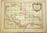 |
Rizzi-Zannoni, Giovanni A., Carte Geo-Hydrographique du Golfe du Méxique et de ses Isles… Paris & Bordeaux, 1762. 12.5 x 17.75 in (32 x 45 cm). Copperplate engraving; original outline color. $395.
Giovanni Rizzi-Zannoni (1736-1814) was an Italian geographer and astronomer who worked extensively in France and became the Chief Hydrographer to the Dépôt des cartes et plans de la Marine, successor to J. N. Bellin. Along with Bonne and Janvier he prepared the maps for Hérissant and Lattre’s Atlas Moderne, in which this map was published. It is a nicely detailed chart with rhumb lines.
Worm holes at the top center margin, just touching the neatline, and in the bottom center margin; browned along the sheet edges. |
|
|
|
© 2009-2012 Susan Benjamin Rare Prints & Maps. All Rights Reserved. |
|
|
|
|